| ||||
|
| ||||
|
EUSEBIO
FRANCISCO KINO
 Lived:
1645-1711
Explored California in: 1687-1711
Exploring for: Spain
Explored: by land, a southern route into California
Kino was a Jesuit priest who
founded 29 missions in Sonora (
EARLY HISTORY
Eusebio Francisco Kino (sometimes
spelled Chino) was born in Segno, near Trent,
After some years of missionary
work in
BACKGROUND
In 1687 the Viceroy of New Spain
sent Kino north from Mexico City to found some missions. Kino’s area, known
as Pimería Alta, was the home of the Pima Indians in present-day Sonora,
At first, Kino devoted his energies to building missions. The Tumacacori ruins in Arizona, now a National Monument, was once a mission founded by Kino. In 1700 he established Mission San Xavier del Bac, on the outskirts of what is now Tucson, and this served as a supply point for his explorations.
In addition to his work of converting the Pima Indians to Christianity, Kino started farms and introduced cattle raising here. He brought herds of cattle, horses and sheep to Pimería Alta and gave them to the Indians. This led to the establishment of some large cattle ranches.
KINO’S JOURNEY
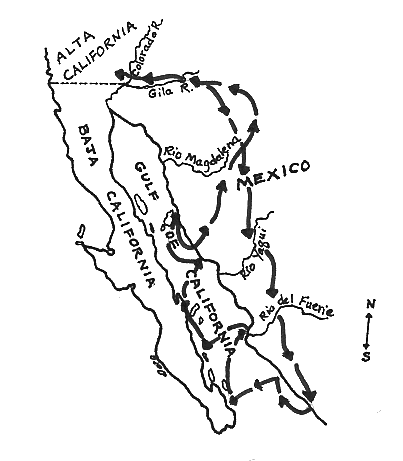
Kino made many journeys through Pimería Alta, mapping the land and finding good routes for trails. In 1699, while on an expedition to the Gila River, Kino was given some blue mother-of-pearl shells. He had seen shells like this just once before, on the Pacific Coast of Baja California in 1685. He knew there were no such shells on the Gulf Coast, and that these shells must have come overland from the Pacific Ocean.
This led Kino to believe that the Indians in southern Arizona had a trade route across California to the ocean. He was most interested in finding this route. He hoped that Pimería Alta could then be a supply place for the Manila galleons that sailed south along the California coast each year. This would bring wealth to Pimería Alta.
Kino made at least 14 expeditions to search for this land route. He traveled thousands of miles on horseback, usually with only a few Indian companions who acted as servants rather than guides. Kino often followed Indian trails, however, and local Indians gave him directions as he journeyed.
By 1701 Kino had proven (as had earlier land explorers in the 1500s) that California was not an island. He had found a route from Arizona to the Pacific Ocean, crossing into California at the place where the Colorado and Gila rivers meet. The map he made of these trails, called Passo por Tierra a la California, was very accurate.
This southern route was not a single trail, but a number of trails which met near the Pima Indian villages on the Gila River in Arizona. From there the trail followed the Gila downstream to where it meets the Colorado River. The trail then turned westward across the desert to the ocean.
Kino gave the name of Alta (Upper)
California to the land lying west of the Colorado River. The border on Kino’s
map between Baja and Alta California is nearly the same as the border between
WHAT HE ACCOMPLISHED
When Americans began exploring west into California, one of the trails they used was the southern overland route. The first part of this trail was mapped by Kino in 1701. His maps were the basis for other maps of the southwest for the next 100 years. Now maps began showing California as a part of the mainland and not as an island.
Kino’s maps and notes ended up in the archives in Mexico City, where they were found in 1908 by a historian, Herbert E. Bolton. Bolton is also the translator of Kino’s Favores Celestiales, which was printed in 1919 as Kino’s Historical Memoir of Pimería Alta.
LATER YEARS
Kino died on March 14, 1711,
at Mission Santa Magdalena in Sonora,
Other Jesuit priests followed Kino’s example of exploration and mapmaking. Father Ugarte, Father Consag, and Father Link all made exploring expeditions in Baja California and around the Colorado River area in the mid-1700s.
The 16 Jesuit priests working
in New Spain were asked to leave the country in 1768. The order came from
Leaving the country, the Jesuit priests turned over their life work to Franciscan and Dominican priests. The next explorations into California would be with Franciscan priests.